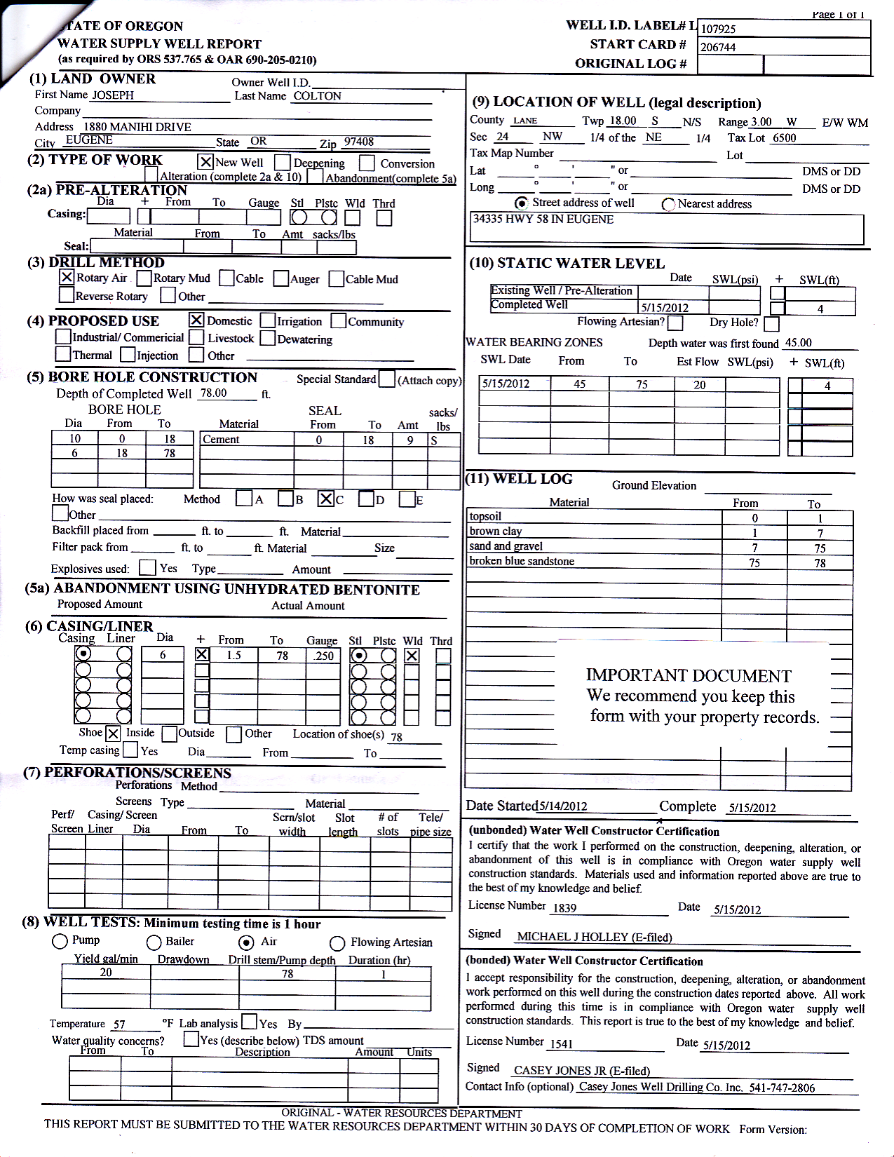
Documents: Well, Survey, Floodway

    Links:   [satellite]   [architect]   [elevation]   [home]

Corner Survey is on file at Lane County: link: http://apps.lanecounty.org/SIDO/FileViewer.aspx?ID=4482969

2012-05-15 Water Supply Well Report, Casey Jones Well Drilling
#1  2012-05-15 Water Supply Well Report, Casey Jones Well Drilling
2013-05-14 Elevation Certificate (4pg), Donn Rowe
#2  2013-05-14 Elevation Certificate (4pg), Donn Rowe
2013-08-09 Floodway Impact Evaluation (40pg), Branch Engineering
#3  2013-08-09 Floodway Impact Evaluation (40pg), Branch Engineering
2013-08-09 Contour Map (1pg), Donn Rowe
#4  2013-08-09 Contour Map (1pg), Donn Rowe
2013-12-26 Corner Survey (1pg), Donn Rowe, 7.48 acres
#5  2013-12-26 Corner Survey (1pg), Donn Rowe, 7.48 acres
Colton Site Survey with True Elevations, surveyed and drawn by Donn Rowe LLC. One foot contours are solid lines and dashed lines are 1/2 foot intervals.
#6  Colton Site Survey with True Elevations, surveyed and drawn by Donn Rowe LLC. One foot contours are solid lines and dashed lines are 1/2 foot intervals.
2013-12-20 Land Use Decision: 100x150 Elevated Building Pad
#7  2013-12-20 Land Use Decision: 100x150 Elevated Building Pad
Elevation Certificate 2014-07-24 Donn Rowe
#8  Elevation Certificate 2014-07-24 Donn Rowe

#9  

Validate:   html5   css3

You are visitor number to this page.
9 items. This page was last updated 2018-08-06 15:21:36 MDT.